Tuesday, January 29, 2013

Deo Hai Van Pass Vietnam


HOME PAGE


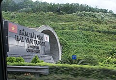
Deo Hai Van is known to the locals as "ocean cloud pass." Its name refers to the mists that rise from the sea, reducing visibility. 


Connecting Hue Province and Danang City, the twisting road on the pass has long been a challenge for drivers. Since the completion of Hai Van Tunnel, traffic flow and safety have improved.


Before the days of the Hai Van Tunnel, one can imagine how much drivers resist from looking away from this narrow road, curvy, laneless and no guard rails whatsoever.


The Hai Van Pass crosses over a spur of the Truong Son (Annamite) Range that emerges from the west and juts into the east Sea, forming the Hai Van Peninsula and the adjoining Son Tra Island. The pass, which once formed the boundary between the kingdoms of Dai Viet and Champa, also forms a boundary between the climates of northern and southern Vietnam, sheltering the city of Da Nang from the northwest winds. During the winter months (November–March), for instance, weather on the north side of the pass might be wet and cold, while the south side might be warm and dry.


The Deo Hai Van Pass dated back to the 1st century when the Chinese general Ma Yuan (Mã Viện), after pacifying northern Vietnam, advanced south and established the southern border of the Han (Hán) empire by setting up columns of bronze. 


The pass has since become a strategic importance in the history of Vietnam, and for a long time represented as a major barrier to any land army that attempted to move between the northern and central regions of the country.


Rote planning and design work for the Hai Van Tunnel started in January 1998 by a joint venture between Nippon Koei Company Ltd., Japan and Louis Berger International Inc., USA with the Vietnamese Transport Engineering Design Inc. (TEDI) providing consultation on the project. 

The tunnel now saves people from the chilling fears its past used to pose upon them.

Updated: 07/14/2014

World's Snakiest Roads

Hold Your Breath!

Oberalp Pass, Switzerland: Open only in the summer, it is unquestionable due to the snow. Located high up in the Swiss Alps. 

Trollstigen, Norway: Despite its steep incline and 11 hairpins, some 7,000 cars travel up the mountain every day at the peak of  tourist season. Breathtaking views of the Isterdalen Valley and the surrounding mountains.

Deo Hai Van Pass, Vietnam: Known to the locals as "ocean cloud pass." Its name refers to the mists that rise from the sea, reducing visibility. Connecting Hue Province and Danang City, the twisting roads on the pass has long been a challenge for drivers. Since the completion of Hai Van Tunnel, traffic flow and safety have improved.

North Yungas Road, Bolivia: Villagers here in the Bolivian Andes Mountains call it "El Camino de la Muerte," or "the Road of Death." Hundreds of people lose their lives every year here, plunging off the road and into the deep canyons of the Coroico River Valley. It is most dangerous when it's foggy and rainy.

Guoliang Tunnel Road, China: Built by the local villagers here to connect Guoliang with the outside world, and since then it becomes a magnet for thousands of tourists every year. It's been called the "road that does not tolerate any mistake," only 12 feet wide and is one of the world's most dangerous road known.


San Bernardino Pass, Switzerland: four-mile-long  tunnel opened in the late 1960s, however, today it's no longer necessary to travel this mountain pass, which dated back to 15th century.


Los Caracoles Pass, Andes Mountains, Chile/Argentina: Despite lack of guard rails and many tight switchbacks, the locals do manage with their usual safety measures. It's closed for much of the year due to snow anyway. Open only some time during  summer months.

Col de Turini, France, with the mind challenge by more than 30 tight hairpin turns, it is a favorite location over the years. The Monte Carlo Rally auto racing championship and cycling's Tour de France has been staged on this mile-high mountain pass road three times.

Jebel Hafeet Mountain Road, United Arab Emirates, despite its steep 8% incline, cyclists travel here to train and to take part in the Jebel Hafeet Mercure Challenge, a duathlon race (running and cycling), that takes place here every year.

Transfagarasan, Romania, S-shaped curves and plenty of tight hairpin turns, keep traffic crawling along most of the time.

Stelvio Pass, Italy, features 60 hairpin turns winding near the Italian-Swiss border, 48 of which lie on the northern side of the pass and are numbered with rocks along the sides of the road.


Lysebotn Road, Norway: Open only from May through November due to frequent snow throughout the year.


Updated: 09/18/2013


Road Connecting the Dots


Atlantic Road, Norway


Nestled along the stretch of coastline known as the Hustadvika in the Western Fjords of Norway, the Atlantic Road is famed for its panoramic views of the islands between the towns of Kristiansund and Molde, where whales and seals can be spotted from the viewing points on the five-mile-long highway.
The road rises and falls with the contours of the land in many places, and can become perilous when the weather turns stormy, sending waves crashing onto the highway.

The Atlantic Ocean Road or the Atlantic Road (Norwegian: Atlanterhavsveien) is a 8.3-kilometer (5.2 mi) long section of County Road 64 which runs through an archipelago in Eide and Averøy in Møre og Romsdal, Norway. 

The fixed link passes by Hustadvika, an unsheltered part of the Norwegian Sea, connecting the island of Averøy with the mainland and Romsdalshalvøya peninsula. The road runs between the villages of Kårvåg on Averøy and Vevang in Eida. 

The road is built on several small islands and skerries, which are connected by several causeways, viaducts and eight bridges—the most prominent being Storseisundet Bridge.

The route was originally proposed as a railway line in the early 20th century, but this was ultimately abandoned. Serious planning of the road started in the 1970s, and construction started on 1 August 1983. During construction, the area was hit by twelve hurricanes. The road was opened on 7 July 1989, having cost 122 million Norwegian krone (NOK), of which 25 percent was financed with tolls and the rest from public grants. Collection of tolls was scheduled to run for 15 years, but by June 1999 the road was paid off and the toll removed. The road is preserved as a cultural heritage site and is classified as a National Tourist Route. It is a popular site to film automotive commercials, has been declared the world's best road trip, and been awarded the title as "Norwegian Construction of the Century". In 2009, the Atlantic Ocean Tunnel opened from Averøy to Kristiansund; combined, they have become a second fixed link between Kristiansund and MoldeCo.


Updated: 09/18/2013

Driving Along the Sea


Welcome to the Pacific Coast Highway, California U.S.A.

Cyclists cross the Bixby Bridge on the Pacific Coast Highway during the Amgen Tour of California.

Coming to the Pacific Coast Highway, you'll be entertained by the sound of sea breeze and the chopping of waters. Just roll down the windows.

Although it may be faster to travel on Route 5, Route 1 offers a longer yet enjoyable drive from north to south. But watch out, in some parts of the way curves along the sea line and are narrow.

One of the crown jewels of America's national scenic byways system, the Pacific Coast Highway stretches just over 120 miles between Monterey and Morro Bay, Calif., towering over the waves crashing into the shore below.


1932 Summer Olympics

For the 1932 Summer Olympics, the segment of the Highway 1 between Oxnard and Santa Monica (then known as the Theodore Roosevelt Highway) hosted part of the road cycling events.


Spots to see along this five-hour drive include Carmel-by-the-Sea and the Monterey Peninsula, as well as the Bixby Bridge in Big Sur, one of the most beautiful places in all of California.


Frequent landslides and erosion along the coast have caused several segments to be re-routed further inland. 

Runs along the Pacific coastline,  from Mendocino County going south to Orange County. 


It is famous for running along some of the most beautiful coastlines in the USA, leading to its designation as an All-American Road


Updated: 10/03/2013

Museum Without Walls

Red Rock Scenic Byway, Sedona, Arizona


Known as the Red Rock Country of central Arizona is home to a road that's often called a "museum without walls," the Red Rock Scenic Byway, an official highway Route 179. 

Stretching between Sedona and its southern terminus at Interstate 17, a short drive that offers stunning views of the area's red rock mesas and nearby Mingus Mountains.


The Red Rock Scenic Byway is your Gateway to the world-famous Red Rock Country of Sedona,Arizona..just 110 miles north of Phoenix and only   hours south of the Grand Canyon.

You'll want to plan for plenty of time to stop and take photos, and to see places just off the highway like the ruins of Montezuma Castle National Monument.

 In 2006, the US Dept. of Transportation awarded SR 179 its highest designation within the National Scenic Byways Program: the All-American Road designation, due to the red rock and sandstone formations.


State Route 179 markerThe All-American Road designation also signifies to the travelling public that this is a road that is "a destination unto itself." Rank #7 on America's top ten scenic byways on Comcast Xfinity's top 10 list it is described as a stretch of highway that offers views which seem to come from another world.


Updated: 09/18/2013

Ocean Highway

 Florida's Overseas Highway was one of the world's longest bridges 
If you arrive on the highway at the right time, you can see some of the most awe-inspiring sunrises and sunsets anywhere in the country. Be prepared to idle on the highway if you come during the high tourist season, however. A drive that usually takes about four hours to complete can take quite a bit longer, especially on holiday weekends.
Also known as the Seven Mile Bridge
Constructed in 1938 to replace what was once the Overseas Railroad  (built 1912)-- which was destroyed by the Labor Day Hurricane that swept through the Florida Keys in 1935 -- the Overseas Highway stretches nearly 130 miles from end to end, mostly over water across 42 bridges between Key Largo and Key West.
It is a 127.5-mile (205.2 km) highway carrying U.S. Route 1 (US 1) through the Florida Keys. Large parts of it were built on the former right-of-way of the Overseas Railroad, the Key West Extension of the Florida East Coast Railway
The construction of the Overseas Highway and Railway Bridges was very important to the economic development of the Florida Keys. The bridges are significant surviving elements of Henry Flagler's Florida East Coast Railway intended to open the Florida coast for development. Begun in 1905 and completed in 1912, the bridges were intended to connect the Florida Keys to the mainland. The construction of Key Bridge began in 1906 and was completed in 1907; the 6.7 mile long Knight Key Bridge was constructed from 1909 to 1912; and the Old Bahia Honda Bridge (no longer in use), was also constructed from 1909 to 1912. The railroad extension was short-lived. The 1935 severe hurricane hit the area and destroyed more than 30 miles of track. In the following years, the bridges were restored and converted from rail to vehicular traffic. The bridges helped open the area to tourism and today are part of U.S. Highway 1 connecting the Florida Keys to the mainland. Because of their remote location and the construction techniques employed, experts consider the bridges to be significant engineering achievements.

Georgia MapThe Florida East Coast Railway was financially unable to restore the destroyed sections, the state of Florida took over ownership for $640,000.


Updated: 09/18/2013

Mounted Highway


The world's tallest bridge, the Millau Viaduct stretches across the Tarn River valley in southern France.

Millau Bridge
It wind through mountain passes, across deserts then over stretches of the ocean. Some were built on top of centuries-old footpaths carved into hillsides, while others connect cities and countries across spans that previously had been impassable.
.Millau Viaduct Fast Facts
  • Opened December 2004,
  • Highest bridge in the world, 
  • More than 340 meters at its highest mast,
  • Slightly taller than the Eiffel Tower, but...
  • Closed to pedestrians.


Millau Viaduct Location

Millau Viaduct bridge viewing areaThe Millau Viaduct is part of the freeway from Paris to Montpellier, and is located in southern France.

One of the best places from which to view the bridge is the Service Area on the northern side of the bridge off the freeway. The climb to the viewing platform is a little strenuous but very worthwhile - and don't forget to bring your camera!

Also it can be quite windy at the viewing area so you do need to bring warm clothing. From the visitor center at the base of the bridge, you'll have a completely different perspective on the Millau Viaduct and is where you can truly appreciate the full height of the towers.


The Millau ViaductThey charge a toll to cross the bridge. You cannot walk across the bridge as it part of the motorway system. 

Millau ViaductIt is a cable-stayed road bridge designed by engineer Michel Virlogeux and architect Norman Foster,

Source: CarsRoute, weather.com, wikipedia.org

Noteable Events and Culture

A run took place in 2004 and another on 13 May 2007:
December 2004 – 19,000 walkers and runners of the Three Bridge Walk had the privilege of crossing the bridge deck for the first time, but the walk was not authorised to go further than pylon P1; the bridge was still closed to traffic.

13 May 2007 – Ten thousand runners took the race which 
starting from the southern end of the viaduct. After on the northern side, they crossed the viaduct then retraced their steps. Total distance: 23.7 km (14.7 mi).

In 2004, a fire started on the slope of causse rouges because of a spark originating from a welder. Some trees were destroyed in the fire.

The Chinese transport minister at the time visited the bridge on the first anniversary of its opening. Although impressed by the technical prowess and the financial assembly of the viaduct, he did not envisage building a counterpart in People's Republic of China.

Featured in a scene of the film Mr. Bean's Holiday. Hosts of the British motoring show, Top Gear, featured the bridge during Series 7, when they took a Ford GT, Pagani Zonda, and Ferrari F430 Spyder on a road trip across France. Richard Hammond, one of the hosts, explored the engineering aspects in the construction of the Millau Viaduct in Series 2 of Richard Hammond's Engineering Connections.


Millau (3).JPG  Millau (10).JPG  Millau (19).JPG  Millau (21).JPG


Updated: 09/18/2013